
Tập tin:Four Southern Hemisphere Tropical Cyclones (2003).jpg

Tập tin gốc (10.800×6.800 điểm ảnh, kích thước tập tin: 18,06 MB, kiểu MIME: image/jpeg)
| Cảnh báo | Một số trình duyệt có thể gặp trở ngại trong việc hiển thị hình này ở cỡ đầy đủ. Hình này có một số lượng điểm ảnh lớn và có thể không được tải chính xác hoặc làm trình duyệt bị treo. |
|---|
Miêu tả
| Miêu tả |
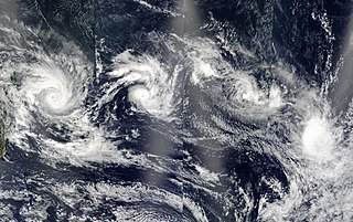
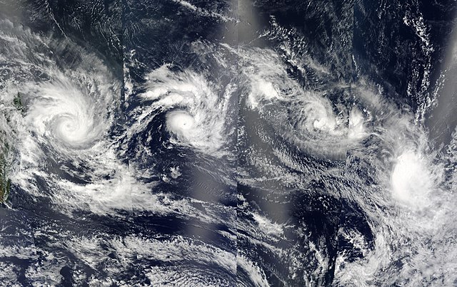
A train of four tropical cyclones is still lined up in the southern Indian Ocean east of Madagascar (left) on Feb. 12, 2003. This true-color image of the storms was made from observations collected by alternating passes of the Aqua and Terra satellites. The cyclones pictured are (east to west) Gerry, Hape, 18S (Pre-Cyclone Isha), and Fiona. Each of the storms appears to have followed the track predicted for it at the time of the first image in the series, captured on Feb, 11. In this image, the storms are generally east or southeast of where there were previously. Terra passed over this area in the morning, moving east to west, and contributing the second and fourth chunks of the image (from right to left). Aqua passed over in the afternoon, also moving east to west, contributing the first and third chunks. |
|||||
| Ngày | ||||||
| Nguồn gốc | http://visibleearth.nasa.gov/view_rec.php?id=4941 | |||||
| Tác giả | Jeff Schmaltz, MODIS Rapid Response Team, NASA/GSFC | |||||
| Giấy phép (Dùng lại tập tin) |
|
|||||
| Phiên bản khác |

.jpg)

.jpg)
Lịch sử tập tin
Nhấn vào ngày/giờ để xem nội dung tập tin tại thời điểm đó.
| Ngày/Giờ | Hình xem trước | Kích cỡ | Thành viên | Miêu tả | |
|---|---|---|---|---|---|
| hiện tại | 19:16, ngày 6 tháng 12 năm 2006 | | 10.800×6.800 (18,06 MB) | Good kitty | Reverted to earlier revision |
| 19:16, ngày 6 tháng 12 năm 2006 |  | 10.800×6.800 (18,06 MB) | Good kitty | Reverted to earlier revision | |
| 16:41, ngày 6 tháng 12 năm 2006 |  | 1.111×700 (201 kB) | Yuval CT | resisized to 1111x700 | |
| 15:06, ngày 1 tháng 9 năm 2006 |  | 10.800×6.800 (18,06 MB) | Good kitty | ||
| 01:07, ngày 3 tháng 1 năm 2006 |  | 600×315 (83 kB) | Hurricanehink | From https://metoc.npmoc.navy.mil/jtwc/atcr/2003atcr/, this MODIS true color satellite image shows Cyclone Gerry, Cyclone Hape, Tropical Storm Isha, and Tropical Storm Fiona on February 12, 2003. {{PD-USGov-NOAA}} {{NOAA logo}} [[Category:Southern hemi |
Trang sử dụng tập tin
Không có trang nào sử dụng tập tin này.
Sử dụng tập tin toàn cục
Những wiki sau đang sử dụng tập tin này:
- Trang sử dụng tại en.wikipedia.org
- Portal:Tropical cyclones/Anniversaries/February
- Portal:Tropical cyclones/Anniversaries/February/12
- Portal:Tropical cyclones/Selected image/15
- 2002–03 South-West Indian Ocean cyclone season
- Wikipedia:Good topics
- Wikipedia:Featured and good topic candidates/2002–03 South-West Indian Ocean cyclone season/archive1
- Wikipedia:Featured and good topic candidates/Featured log/July 2013
- Wikipedia:Featured and good topic candidates/Good log/July 2013
- Wikipedia:Featured topics/2002–03 South-West Indian Ocean cyclone season
- Tropical cyclones in 2003
- Portal:Tropical cyclones/Selected image
- Weather of 2003
.jpg)