
Tập tin:Kuala Lumpur at dawn (18794580599).jpg

Tập tin gốc (7.360×4.912 điểm ảnh, kích thước tập tin: 2,33 MB, kiểu MIME: image/jpeg)
.jpg)
Miêu tả
| Miêu tả |
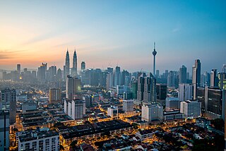
English: Kuala Lumpur is the national capital and most populous city in Malaysia. The city covers an area of 243 km2 and has an estimated population of 1.6 million as of 2010. Greater Kuala Lumpur, covering similar area as the Klang Valley, is an urban agglomeration of 7.5 million people as of 2012. It is among the fastest growing metropolitan regions in South-East Asia, in terms of population and economy.
Kuala Lumpur is the seat of the Parliament of Malaysia. The city was once home to the executive and judicial branches of the federal government, but they were moved to Putrajaya in early 1999. Some sections of the judiciary still remain in the capital city of Kuala Lumpur. The official residence of the Malaysian King, the Istana Negara, is also situated in Kuala Lumpur. Rated as an alpha world city, Kuala Lumpur is the cultural, financial and economic centre of Malaysia due to its position as the capital as well as being a key city. Kuala Lumpur was ranked 48th among global cities by Foreign Policy's 2010 Global Cities Index and was ranked 67th among global cities for economic and social innovation by the 2thinknow Innovation Cities Index in 2010. Since the 1990s, the city has played host to many international sporting, political and cultural events including the 1998 Commonwealth Games and the Formula One Grand Prix. In addition, Kuala Lumpur is home to the tallest twin buildings in the world, the Petronas Twin Towers, which have become an iconic symbol of Malaysia's futuristic development [Wikipedia.org] |
| Ngày | |
| Nguồn gốc | Kuala Lumpur at dawn |
| Tác giả | Jorge Láscar from Melbourne, Australia |
| Vị trí máy chụp hình | | Xem hình này và các hình ảnh lân cận trên: OpenStreetMap |
|---|
.jpg¶ms=003.156242_N_0101.713056_E_globe:Earth_type:camera_source:Flickr_&language=vi)
Giấy phép
- Bạn được phép:
- chia sẻ – sao chép, phân phối và chuyển giao tác phẩm
- pha trộn – để chuyển thể tác phẩm
- Theo các điều kiện sau:
- ghi công – Bạn phải ghi lại tác giả và nguồn, liên kết đến giấy phép, và các thay đổi đã được thực hiện, nếu có. Bạn có thể làm các điều trên bằng bất kỳ cách hợp lý nào, miễn sao không ám chỉ rằng người cho giấy phép ủng hộ bạn hay việc sử dụng của bạn.
| Hình này, ban đầu được tải lên tại Flickr bởi Jorge Lascar vào https://flickr.com/photos/8721758@N06/18794580599 (archive). Tập tin đã được FlickreviewR 2 kiểm tra vào 2 tháng 2 năm 2018 và xác nhận rằng nó tuân theo các điều khoản của cc-by-2.0. |
Lịch sử tập tin
Nhấn vào ngày/giờ để xem nội dung tập tin tại thời điểm đó.
| Ngày/Giờ | Hình xem trước | Kích cỡ | Thành viên | Miêu tả | |
|---|---|---|---|---|---|
| hiện tại | 10:28, ngày 2 tháng 2 năm 2018 | | 7.360×4.912 (2,33 MB) | Thesupermat2 | Transferred from Flickr via Flickr2Commons |
Trang sử dụng tập tin
Trang sau sử dụng tập tin này:
Sử dụng tập tin toàn cục
Những wiki sau đang sử dụng tập tin này:
- Trang sử dụng tại bn.wikipedia.org
- Trang sử dụng tại bo.wikipedia.org
- Trang sử dụng tại en.wikipedia.org
- Kuala Lumpur
- Kajang
- Demographics of Malaysia
- Geography of Malaysia
- Shah Alam
- George Town, Penang
- List of cities in Malaysia
- Ipoh
- Kota Kinabalu
- Johor Bahru
- Klang (city)
- Kuantan
- Petaling Jaya
- Sungai Petani
- Alor Setar
- Subang Jaya
- Malacca City
- Tawau
- Portal:Malaysia
- Seberang Perai
- Iskandar Puteri
- Malaysia
- Lists of cities by country
- Ampang Jaya
- Portal:Malaysia/Topics
- Selayang
- Template:Largest cities of Malaysia
- Seremban
- User:Joothis
- List of megalopolises
- Trang sử dụng tại fr.wikipedia.org
- Trang sử dụng tại hu.wikipedia.org
- Trang sử dụng tại id.wikipedia.org
- Trang sử dụng tại io.wikipedia.org
- Trang sử dụng tại ml.wikipedia.org
- Trang sử dụng tại no.wikipedia.org
- Trang sử dụng tại ta.wikipedia.org
- Trang sử dụng tại th.wikipedia.org
Xem thêm các trang toàn cục sử dụng tập tin này.
.jpg)
.jpg)